 By Beth Mack
July 29, 2021
When people think of Charlotte, they often focus on the hustle and bustle of Uptown and its towering skyline, and overlook the 307 square miles that reside within its city limits. One of the best ways to explore the expanse of Charlotte is on foot or by bike. Whether you’re looking to take into the sights and sounds of the city or a more serene nature setting, Charlotte and its surrounding areas offer tons of trails, greenways, and preserves right around the corner for you to explore.

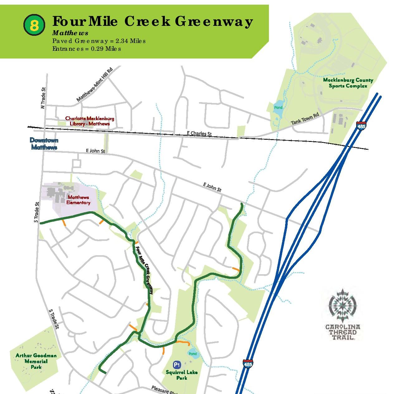
Four Mile Creek Greenway
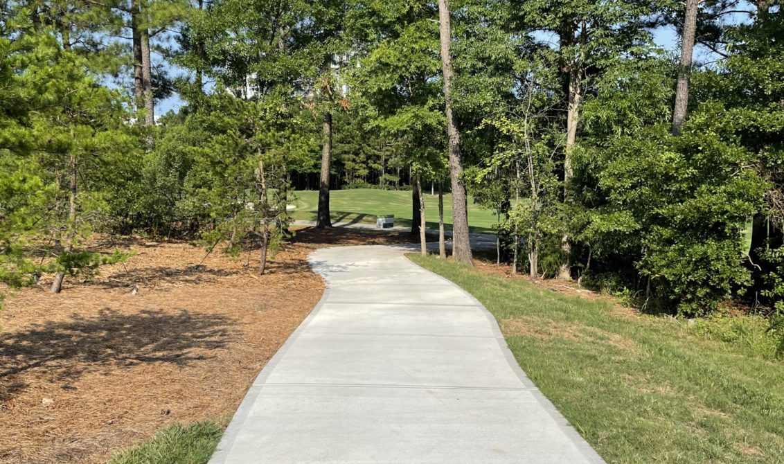
Managed by Mecklenburg County Parks and Recreation, the Four Mile Creek Greenway in Matthews winds along a creek and wooded areas with a boardwalk over wetlands. The paved trail can be picked up on East John Street, and journeys through Squirrel Lake Park till it connects to South Trade Street offering a serene escape for walkers, runners, and bikers.
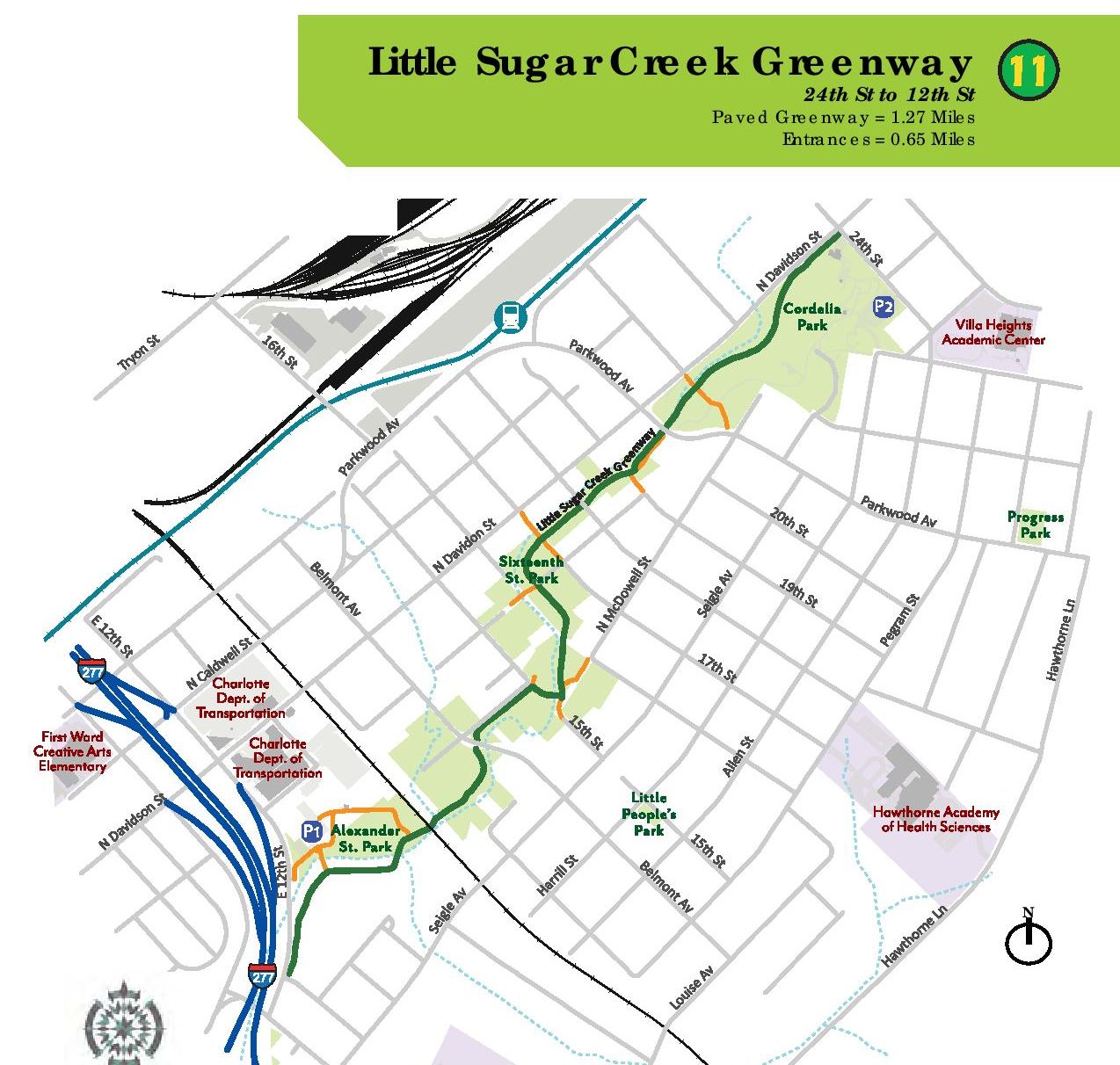
Little Sugar Creek Greenway
Little Sugar Creek Greenway offers a roughly eight-mile round trip tour de Charlotte. While not complete, the largest and most frequented section starts on 7th Street at CPCC and winds along the creek through Midtown Park, Freedom Park, and ends on Brandywine Road in Montford. The paved trail with minimal incline is suitable for all walks and wheels, ranging for those looking for a medium distance run to those on a leisurely stroll.
McDowell Creek Greenway
Tucked along the edge of the bustling Birkdale Village, the trailhead to the McDowell Creek Greenway will transport you to a green oasis. The three-mile out-and-back paved trail winds along the creek from Sam Furr Road to Westmoreland Road through woods and fields ideal for walkers, runners, and bikers of all fitness levels.

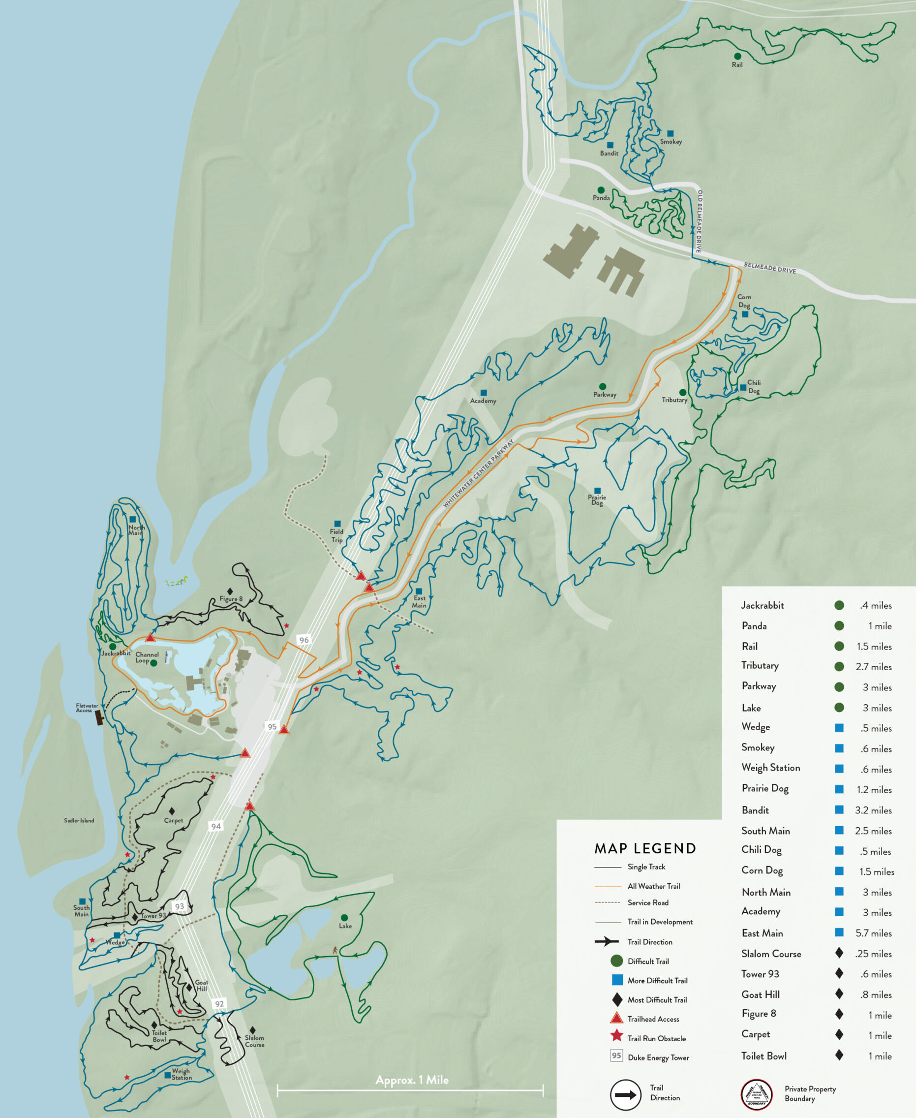
U.S. National Whitewater Center
Charlotte’s mecca for outdoor activities boasts over 50 miles of trails fit for mountain biking, hiking, and trail running. Trails range in length from the Jackrabbit (0.4 miles) up to the East Main (5.7 miles), all of which are rated by level of difficulty. While you will have to pay for parking, their trail system is free to use and for those without a bike, they offer ones you can rent at the Trail Center. Due to inclement weather, they may elect to close the trails so be sure to check their website before heading out.
Mallard Creek and Clark’s Creek Greenway
Providing a respite from the hustle of the University area, these two greenways provide a combined 7.4 miles of trails that weave along creeks, meadows, and wooded areas. Pick up the trail at Kirk Farm Fields near UNC Charlotte and follow paved and gravel trails under I-85 and through University Research Park, as it travels north ending in the Prosperity Church Road neighborhood.
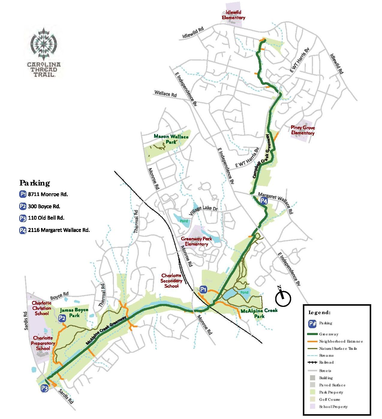
McAlpine Creek Park + Greenway
For a venture into south Charlotte, check out McAlpine Creek Park located just off of Independence Boulevard. The 114-acre park features bike trails, nature trails, and a 5k championship cross-country course in addition to a dog park and three-acre lake. In addition, the paved McAlpine Creek Greenway runs through the middle of the park following along the creek. Follow the greenway north and it turns into Campbell Creek Greenway, or south until the trail ends at Sardis Road.
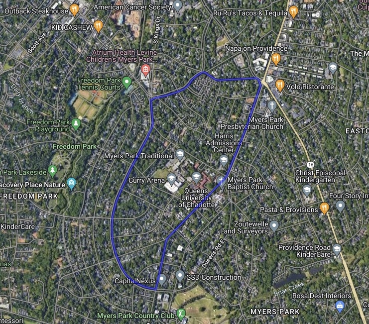
Booty Loop
One of Charlotte’s most well-known running and biking loops takes its visitors on a three-mile loop tour of the Myers Park neighborhood. Whether you opt for paved streets or sidewalks, you can take in the sights of several historic mansions and Queens University of Charlotte along the curvy, hilly route comprised of Selwyn Avenue, Queens Road, and Queens Road West. For cycling enthusiasts, the Booty Loop is the site of the annual cycling fundraiser, 24 Hours of Booty.
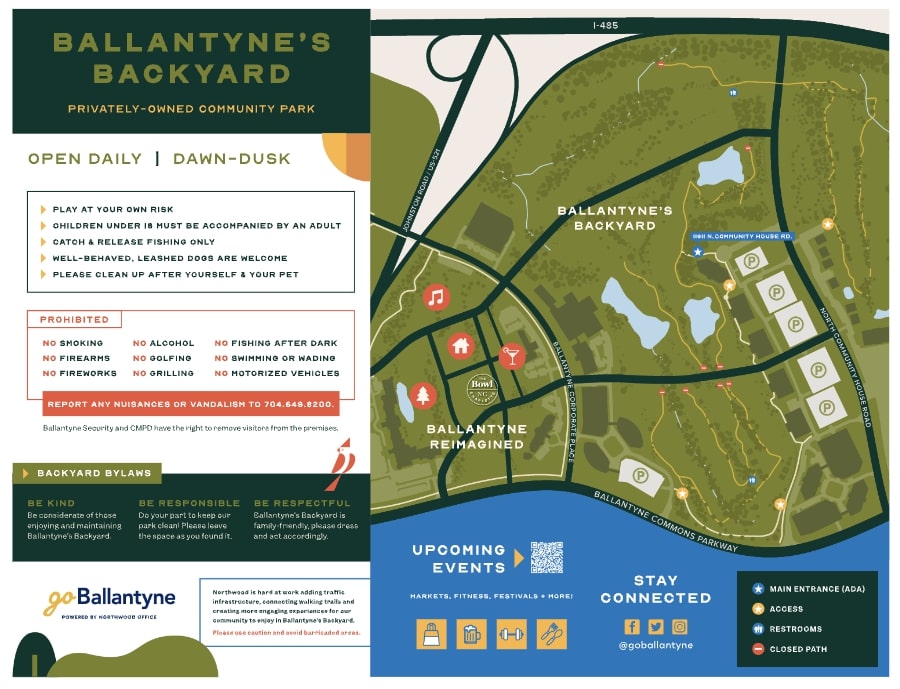
Ballantyne’s Back Yard
The former Ballantyne Golf Course has recently been transformed to a community park, creating a serene green space right in the middle of Ballantyne Corporate Park. The privately-owned community park boasts over 100 acres of green space with miles of former cart trails transitioned into paths for walking, running, and biking. Future park developments and events are in the works, but the trails are ready for your adventure. The best way to access the park is by utilizing the designated parking located at 11611 N Community House Rd.
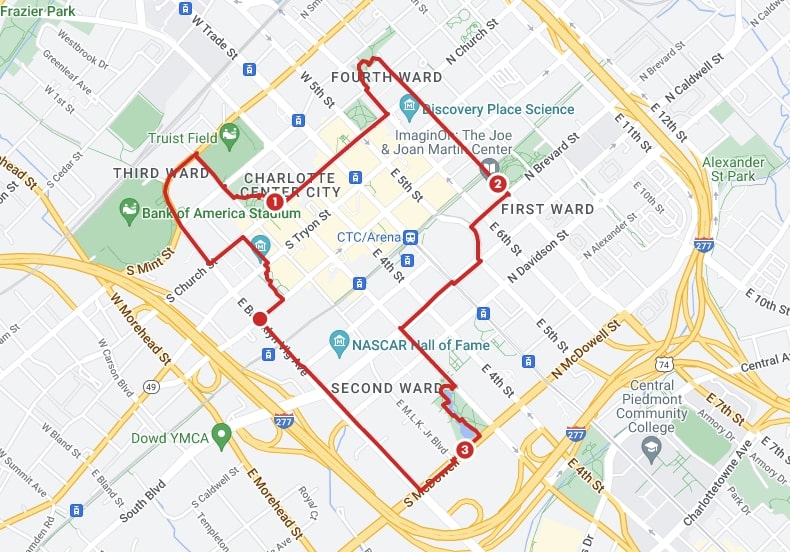
Uptown Parks and Stadiums Loop
If you want to hit all of Uptown’s major parks and stadiums, this is the route for you. You can pick up the loop at any stadium Uptown to begin your Uptown tour de Charlotte. The 3.7-mile loop shows off Bank of America Stadium, Truist Field, Romare Bearden Park, Fourth Ward Park, First Ward Park, Spectrum Center, Marshall Park, and the NASCAR Hall of Fame. While there may be some stop-and-go waiting at traffic lights, there are plenty of places to pick up refreshments along the way.
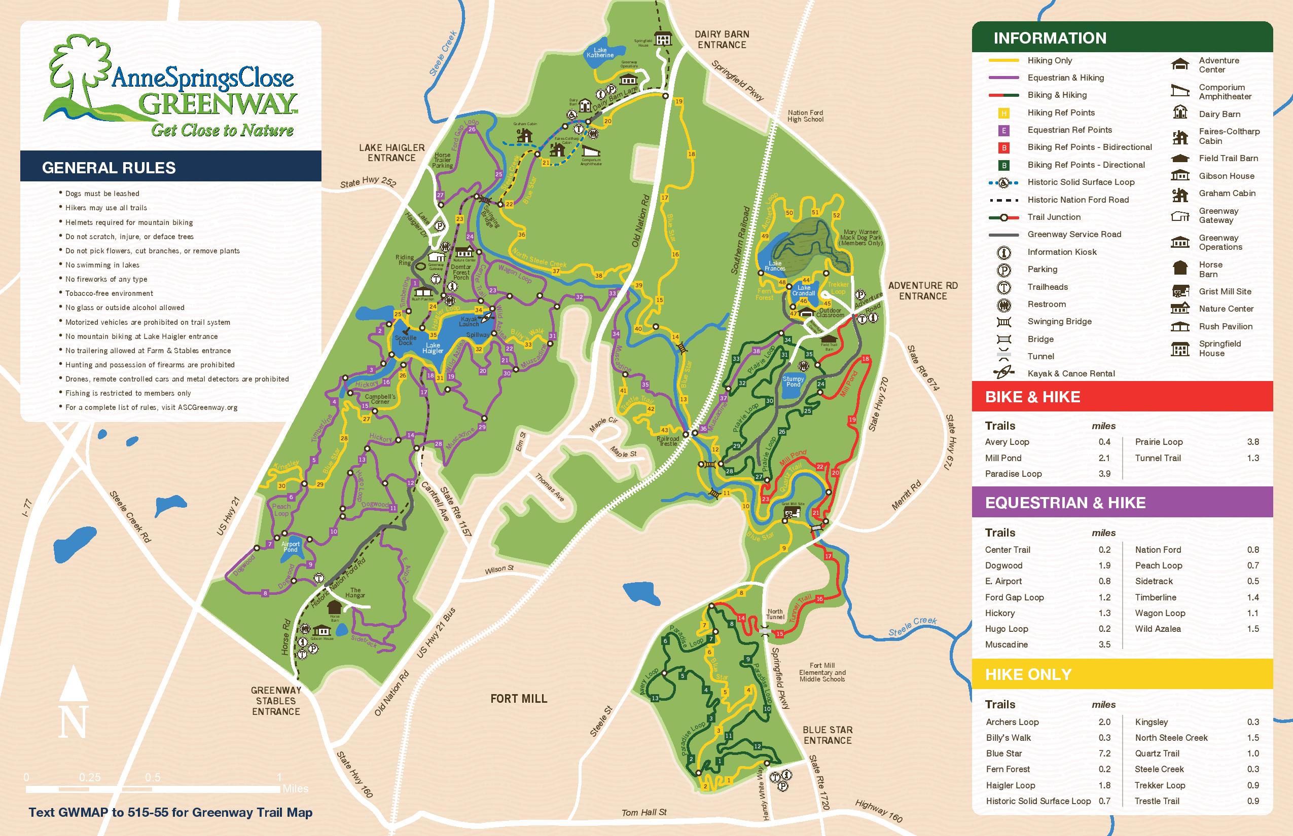
Anne Springs Close Greenway
Located on a sprawling 2,100 acre nature preserve in Rock Hill, Anne Close Springs (ASC) Greenway, offers 36 miles of hiking and mountain biking trails. The park operates as a non profit and offers trails that range in length from 0.3 miles up to 7.2 miles and are a mixture of paved, gravel, and natural trails. The preserve also features a lake where you can rent kayaks and paddleboards, as well as a canteen where you can grab a bite to eat. To help support this nonprofit’s vision of nature preservation, there is a $6 daily fee to access its trails.
Charlotte Rail Trail
Take in the sights of Uptown and South End on this trail while traveling alongside the LYNX Blue Line for 3.5 miles. Also known as the Trolley Trail, the paved trail starts in Uptown at the 9th Street LYNX station, travels through the heart of South End, and ends near Clanton Road. This is one of the best trails for the art enthused as it offers a glimpse of some of Charlotte’s most well-known public art installations and murals along the way. If you need a break, stop by the plethora of cafes, restaurants, or breweries in South End, or cool down with Jeni’s Ice Cream. The city is currently in the process of finalizing plans to construct a pedestrian bridge over I-277 that will connect Uptown to South End, eliminating the need to detour around it.
Read next: